Unlock Accuracy at Unprecedented Speed
Discover the future of construction surveying with the Smart Construction Edge 2 & Drone — your next leap in accuracy and efficiency. Our latest Edge 2 & drone technology offers you a 60% faster surveying experience than traditional methods, with precision that lets no detail go unnoticed, no matter the terrain.
Why choose Edge 2?
Fast | User-Friendly | Intelligent | Versatile
• Faster data processing: Immediate infield data processing means no downtime. Return to the office with ready-to-use data, accurate 3d point clouds, and quality orthophotos.
• Simplified operations: From the 'Self-Position' feature to AI-powered object removal, SC Edge 2 is designed to make your job easier without compromising on accuracy or control.
• Intelligent design: SC Edge 2 isn’t just a tool, it’s a survey partner. Check and adjust point clouds in the field, ensuring perfect vertical accuracy of every flight.
• Enhanced versatility: Whether serving as a base station to fly in RTK mode with your drone or connecting seamlessly with other GNSS equipment, SC Edge 2 is your all-in-one solution for comprehensive aerial survey solution.
Seamless integration, unmatched output
Explore features that set Edge 2 apart:
• Effortless setup: Start easily with features like the “Self Position” or the "Known Point" function for quick and easy setup.
• AI-driven clarity: Remove unwanted objects automatically, ensuring clean data every time.
• Vertical accuracy check: Instantly verify data accuracy with built-in accuracy check and adjust and reporting.
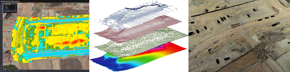
• Cloud connectivity: Send data directly to the SC Dashboard for immediate visualisation and action.
• Safety first: Avoid hazardous data collection methods with a drone designed to prioritise safety without sacrificing detail.
See the difference with Smart Construction Edge 2
• Rapid in-field data: Process and validate your drone data before even leaving the site.
• View progress from above: Monitor your job site with a bird's eye view, enhancing project tracking and management.
• Unlimited potential: With continuous processing capabilities, Edge 2 doesn’t stop until the job is done.
Integrate new surveying technology into your workflow, SC Edge 2 is here to elevate your projects.